Showing posts with label Biodiversity. Show all posts

Wednesday, December 15, 2010

Melting Glaciers to Bring Floods and Drought


Melting Glaciers, CHALLENGE TO HUMAN habitat and LIVELIHOODS


Climate change is causing mass loss of glaciers in high mountains worldwide. Within a few decades, melting glaciers could leave arid areas such as Central Asia and parts of the Andes even drier as the ice melts into water and flows downhill, causing disastrous floods in the lowlands.
Compiled by UNEP's Polar Research Centre, the report says the larger glaciers may take centuries to disappear but many low-lying, smaller glaciers, which are often crucial water sources in dry lands, are melting much faster.
Glacial melt will change the lives of millions as over half of the world's population lives in watersheds of major rivers originating in mountains with glaciers and snow.
Glaciers in Argentina and Chile, followed by those in Alaska and its coastal mountain ranges, have been losing mass faster and for longer than glaciers in other parts of the world, finds the report, "High Mountain Glaciers and Climate Change - Challenges to Human Livelihoods and Adaptation."
Melting more slowly are glaciers in the high mountains of Asia, including the Hindu Kush region of the Himalayas, the Arctic and the Andes.
"These alarming findings on melting glaciers underline the importance of combating climate change globally. It sends a strong message to us as politicians and climate negotiators in Cancun," said Norway's Minister of the Environment and International Development Erik Solheim.
Solheim announced today that Norway will fully fund, with more than US$12 million, the five-year Hindu-Kush-Himalayas Climate Impact Adaptation and Assessment Programme from 2011.
"People in the Himalayas must prepare for a tough and unpredictable future. They need our committed support," said Solheim. "Therefore, Norway will fully fund the brand new five-year program. We see this program as a potent mix of solid climate science, promising intra-regional cooperation and concrete adaptation projects on the ground."
The initiative will be carried out by the Centre for International Climate and Environmental Research, the International Centre for Integrated Mountain Development and UNEP-Grid Arendal.
"Accumulation of science shows us a clear general trend of melting glaciers linked to a warming climate and perhaps other impacts, such as the deposit of soot, reducing the reflection of heat back into space," UNEP Executive Director Achim Steiner said today.
"This report underlines a global trend, observed over many decades now in some parts of the globe, which has short and long-term implications for considerable numbers of people in terms of water supplies and vulnerability," he said.
In dry regions of Central Asia, Chile, Argentina and Peru, where there is little rainfall and precipitation, receding glaciers will have much more impact on the seasonal water availability than in Europe or in parts of Asia, where monsoon rains play a much more prominent role in the water cycle, the report finds.
Some areas are experiencing contradictory effects, according to the report. In smaller areas of Asia's Karakoram range, for example, advancing glaciers have crept over areas that have been free of ice for 50 years. But in Asia's Tianshan and Himalayan mountain ranges, glaciers are receding, and some are shrinking rapidly, causing glacial lakes to burst.
 "Without doubt the main driving force behind the rapid melting of Himalayan glaciers and formation of the catastrophic Glacial Lake Outburst Floods is warming due to climate change," said Madhav Karki, deputy director general of the International Centre for Integrated Mountain Development.
The risk to lives and livelihoods in the fragile Hindu Kush Himalayan region is high and getting higher," said Dr. Karki, expressing thanks to the Norwegian government for its funding of the new adaptation program. "Immediate action by the global community on launching long-term adaptation and resilience-building programs is urgently needed."
In the last 40 years, Glacial Lake Outburst Floods, often called GLOFs, have been increasing, not only in China, Nepal and Bhutan, but also more recently in Patagonia and the Andes.
There has been a near doubling in the frequency of GLOFs in the Yarkant region of Karakoram, China since 1959, attributed to the warming climate.
In the Lunana region of Bhutan on October 7, 1994, the glacial lake Luggye Tsho burst. The ensuing GLOF, which contained an estimated 18 million cubic meters of water, debris and trees, swept downstream killing more than 20 people, and travelled over 204 kilometers.
"When glaciers disappear, people, livestock, birds and animals will be forced to move," says one of the report's editors, Christian Nellemann of the UNEP/GRID-Arendal research center in Norway. "But ironically, a lot of people die in deserts also from drowning, when increasingly unpredictable rains cause flash floods."
"The impact of floods was brought into sharp relief in Pakistan in August 2010. As of November 2010, over six million people were still being affected by this disaster, with many displaced and housing, livelihoods, crops and livestock lost," said Steiner in his introduction to the report.
Siphoning off the water from overflowing lakes is one adaptive action, successfully carried out at lakes in Peru's Cordillera Blanca. Similar projects have been carried out in the Tsho and Thorthormi Glaciers in Nepal and Bhutan but the cost and technical challenges in remote locations can be high.
The report recommends:
  • Strengthening glacial research and trans-national collaboration with emphasis on mass calculation, monitoring and particularly the effects of glacial recession on water resources, biodiversity and availability downstream.
  • Improved modeling on precipitation patterns and effects on water availability in particular in mountain regions of Asia and Latin America.
  • Prioritizing support to and development of adaptation to water-related disasters.
  • Prioritizing programs and support to development and implementation of adaptation strategies for too much and too little water including strengthening the role of women.
  • Urgently supporting the implementation and improvement of both small and large-scale water capture and storage systems and improving efficiency of current irrigation systems through the use of green technology and agricultural knowledge.
"If the world is to decisively deal with climate change, we must also address the need for programmes targeted towards adaptation strategies to build long-term resilience. Local people are already having to make tough decisions and choices as the climate around them changes," said Steiner. "It is time for and governments and the international to step up action on cutting emissions and supporting adaptation. This meeting in Cancun is the next opportunity to fast track a response."
----
Disclaimer: The views expressed in this article are the sole responsibility of the author and do not necessarily reflect those of the ‘Wonders of Pakistan’. The contents of this article too are the sole responsibility of the author(s). WoP will not be responsible or liable for any inaccurate or incorrect statements contained in this post.
YOUR COMMENT IS IMPORTANT
DO NOT UNDERESTIMATE THE POWER OF YOUR COMMENT
Wonders of Pakistan supports freedom of expression and this commitment extends to our readers as well. Constraints however, apply in case of a violation of WoP Comments Policy. We also moderate hate speech, libel and gratuitous insults.


Can Animals Sense Earthquakes Before They Strike?


.A new study suggests toads can detect impending earthquakes, calling to mind other examples of animals sensing disasters before they hit.


n April 2009, British researchers were studying the common toad at a breeding site in central Italy when they “observed a mass exodus of toads,” Jill Lawless reports for the Associated Press.

Just five days later, a 
6.3-magnitude earthquake hit, killing some 150 people and causing extensive damage to the town of L’Aquila. 

Rachel Grant, a researcher at Open University and lead author of one of the first studies to document animal behavior surrounding earthquakes, believes “that toads are able to detect pre-seismic cues such as the release of gases and charged particles, and use these as a form of earthquake early warning system.”

According to the study, “Predicting the unpredictable; evidence of
pre-seismic anticipatory behaviour in the common toad,” the toad population at the breeding site dropped to zero three days prior to the quake. 

“A day after the earthquake, they all started coming back,” Grant told the AP. “The numbers were still lower than normal and remained low until after the last aftershock.”


“The belief that animals can predict earthquakes has been around for centuries,” Maryann Mott wrote for National Geographic News in 2003. In 373 B.C., historians wrote that rats, weasels and snakes made a mass exodus from the Greek city of Helice days before an earthquake destroyed the city. Other examples exist from throughout the centuries. Reports include bees leaving their hive, catfish moving violently and chickens refusing to lay eggs. Pet owners also have examples of their cats and dogs behaving strangely before a quake. 

To date, seismologists can’t predict when or where the next earthquake will hit, and scientists don’t know what, if anything, animals sense before a quake. Some, like Grant, think they can detect changes in the Earth’s gases. Others wonder if animals’ more sensitive hearing and other senses allow them to feel vibrations that humans can’t, or detect electrical changes.

Although some researchers continue to pursue the idea that animals can be used as an early warning prediction system, others remain skeptical. “What we’re faced with is a lot of anecdotes,” Andy Michael, a geophysicist at United States Geological Survey, told Mott. “Animals react to so many things—being hungry, defending their territories, mating, predators—so it’s hard to have a controlled study to get that advanced warning signal.”

The PBS show “Nature” examined the issue in 2005 in “
Can Animals Predict Disaster?” Watch the full episode online to see “ancient ideas about how animals can predict disaster which are now gaining credence in scientific circles.” 


Sources in this Story


Perhaps the most recent and most startling example of animals fleeing before an impending disaster was the 2004 tsunami that devastated the coastlines of India and Sri Lanka.

According to eyewitnesses, elephants screamed and headed for higher ground, flamingoes left their low-lying breeding areas, and zoo animals and dogs refused to go outside, Maryann Mott reported for National Geographic in 2005. Although the tsunami, triggered by a magnitude-9 quake, killed more than 150,000 people, “[r]elatively
few animals have been reported dead,” Mott wrote.

Animals weren’t the only ones who sensed impending disaster. As Bob Simon reported for “60 Minutes” in 2005, “[T]here’s one group who live precisely where the tsunami hit hardest who suffered no casualties at all.” The Moken people, who live a nomadic lifestyle on the Andaman Sea, saw the signs in the sea.

“The water receded very fast and one wave, one small wave, came so they recognized that this is not ordinary,” Dr. Narumon Hinshiranan, an anthropologist who speaks the Moken language, told Simon.

The water wasn’t the only clue. The Moken also noticed that animals were acting strangely: Elephants headed for higher ground and dolphins swam for deeper waters. And the cicadas, “which are usually so loud, suddenly went silent.”

The Moken climbed to higher ground and were saved, while their villages were completely destroyed.


While animals rely on their keen senses, and indigenous tribes like the Moken rely on their intimate knowledge of their immediate environment, scientists continue to struggle to find a reliable earthquake prediction system.

NASA and U.K.-based scientists are working together to investigate the possibility of a satellite-based earthquake warning system that could detect 
electrical changes in the Earth’s atmosphere.

Other seismologists believe that ultrasensitive new instruments that
measure changes in rock could allow them to detect earthquakes hours in advance.

The consequences of earthquakes can be disastrous, especially for impoverished countries. Take a look at the science behind the earthquake and its various effects in history.
---

YOUR COMMENT IS IMPORTANT
DO NOT UNDERESTIMATE THE POWER OF YOUR COMMENT
Wonders of Pakistan supports freedom of expression and this commitment extends to our readers as well. Constraints however, apply in case of a violation of WoP Comments Policy. We also moderate hate speech, libel and gratuitous insults.


Saturday, December 11, 2010

Asia’s Biggest Glacier Cracking Thanks To Military Activity


GIANT CRACKS IN SIACHEN: A SERIOUS THREAT TO CLIMATE 


Arshad H. Abbasi 


New satellite images show growing giant cracks forming through the Siachen Glacier, the second longest glacier on the planet. One of the most serious observations is the formation of a stream.

Development of cracks, streams, and glacial lakes show that glacier may disappear, if immediate measures are not taken by Pakistan and India.

The cause of these cracks is not global warming; rather it is the presence of the Indian army on the Siachen Glacier since 1984.  The glacier is melting at an unprecedented rate and this has already been reported. The melting has been attributed to the deployment of troops and establishment of permanent cantonments. However, decision makers of both countries have turned a deaf ear to this climatic disaster.  The Indian government is trying its best to associate the cause of glacier melting to the phenomenon of global warming, which is undoubtedly baseless and merely a case of evasion of responsibility.

Glaciers melt into glacial lakes, leading to the formation of a stream which later joins the Nubra River. This has been due to attempts by Indian army to facilitate movement of its troops. Indian army is responsible for the cutting and melting of glacial ice through application of chemicals for construction of bunkers. 

SDPI is constantly highlighting this damage that would cause the Siachen glacier and its environment through dumping of chemicals, metals, organic and human waste, and daily leakages from 2000 gallons of kerosene oil. The oil would pass through 250 km of a plastic pipeline, laid by the Indian
army throughout the glacier.

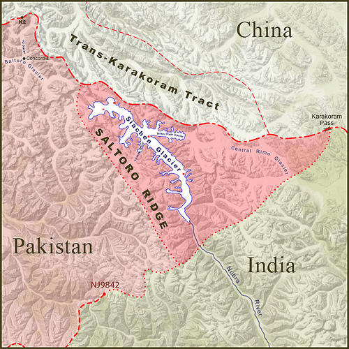
Here it is worth mentioning that this scribe has categorically been denying throughout, all claims by Indian meteorologists that Siachen and other glaciers in Jammu and Kashmir are melting due to the global warming rather than direct human activity. It has been a challenge for scientists working on climate change to understand how the adjoining Baltoro glacier on the other side of Saltoro Ridge which divides the two glaciers, does not seem to be experiencing the same effect.

The causes of recent floods in Pakistan are blamed on El Niño but very less attention is being paid to the cloud burst in Siachen and Ladakh Region, which is because of an uneven development including development of airports and helipads on various locations of glaciers. The unprecedented cloud burst broke all records of rainfall of modern recorded history of meteorological data pertaining to the region. Since last couple of years it was emphasized and urged from the Indian government to save and preserve these glaciers, as these are declared climate change indicators.

Although the scientists agreed that recent territorial monsoon rainfall has been because of the confluence of the Western Monsoon system, they failed to correlate on the reasons behind this atmospheric weather divide. It has been reported in various international research institution that rainfalls caused the 2010 floods in Pakistan. The Ministry of Foreign Affairs never raised the question of melting glaciers, which ultimately appeared disastrous for Pakistan.

In 2005, a team from the University of Newcastle, UK established this after finding out from compilation of temperature data for several instrumental records. The Karakoram and Hindu Kush Mountains of the Upper Indus Basin (UIB) had been analyzed for seasonal and annual trends over the period 1961-2000 and compared with neighboring mountain regions of Pakistan and India. Strong contrasts are found between the behavior of winter and summer temperatures and between maximum and minimum temperatures but decision makers of both countries remained unmoved. This is of particular concern on part of the Ministry of Environment and Ministry of Water and Power, which never took this issue to an international level.

Pakistan Government needs to take the case to the International Court of Justice, as the issue remains to be one of the most potent cases of climate change injustice caused to a neighboring country. An international commission should be established based on neutral climate change experts to fix the responsibility and quantify the impacts. Based on the findings, Pakistan should pursue international community to pressure India for an immediate demilitarization of Siachen and declaration of all glaciers as protected areas.

These glaciers could be handed over to UNESCO or concerned parties to avoid any future calamity. Furthermore, Pakistan should claim financial losses made due to the floods.

SDPI is an independent Pakistani think-tank based in Islamabad.
---

Related Posts: Pakistan, The Largest Land of Glaciers Part 1, 2 and 3

Disclaimer: The views expressed in this article are the sole responsibility of the author and do not necessarily reflect those of the ‘Wonders of Pakistan’. The contents of this article too are the sole responsibility of the author(s). WoP will not be responsible or liable for any inaccurate or incorrect statements contained in this post.
YOUR COMMENT IS IMPORTANT
DO NOT UNDERESTIMATE THE POWER OF YOUR COMMENT
Wonders of Pakistan supports freedom of expression and this commitment extends to our readers as well. Constraints however, apply in case of a violation of WoP Comments Policy. We also moderate hate speech, libel and gratuitous insults.


Monday, January 5, 2009

Pakistan, The Largest Land of Glaciers [Part 1 of 3]

Embedded in the lap of Pakistan's mighty Karakorams (here shown in dark green)  lies Siachen (the small, dark orange part). 


THE LARGEST LAND OF GLACIERS


by Nayyar Hashmey


In Pakistan, we have more glaciers than any other land outside the north and south poles. Our glacial area covers some 13,680 sq. km which represents an average of 13 per cent of mountain regions of the upper Indus Basin. Baltistan, in our north eastern corner and in the heart of Karakorams, provides the world's most magnificent mountain scenery and mountaineering possibilities. Renowned for the largest glaciers and towering peaks, it has four 8000m peaks, and many over 7000m.


The glaciers in Pakistan can rightly claim to possess the greatest mass and collection of glaciated space on the face of earth. In fact, in the lap of our Karakoram mountains alone there are glaciers whose total length would add up to about 6,160 sq. km. To put it more precisely, as high as 37 per cent of the Karakoram area is under its glaciers against Himalayas' 17 per cent and European Alps' 22 per cent. The Karakorams have one more claim to proclaim; its southern flank (east and west of the enormous Biafo glacier) has a concentration of glaciers which works out to 59 per cent of its area.


Eric Shipton, a great mountaineer who perished in Pakistan's Northern Areas, while describing the peaks and glaciers in Pakistan wrote in his account “To describe this region is to indulge in superlatives, for everywhere you look are the highest, the longest and the largest mountains, glaciers and rivers in the world”. Making some allowance for Shipton's tendency towards slight exaggeration, born out of awe and fascination, the fact remains that Pakistan boasts of the largest share of the highest number of glaciers after the poles.

This largest ice mass in the subcontinent however, continues to mar relations between India and Pakistan.
 Located in the disputed region of Kashmir its average winter snowfall is 10.5m (35 ft.) and temperatures can dip to minus 50C (minus 58F). In spite of this severe climate, the word 'Siachen' ironically means 'the place of wild roses, a reference some people attribute to the abundance of Himalayan wildflowers found in the valleys below the glacier, but specifically refers to the thorny wild plants which grow on the rocky outcrops.

Presently the glacier is also the highest battleground on earth, where India and Pakistan have fought intermittently since April 13, 1984. Pakistan maintains permanent military personnel in the region at a height of over 6,000m and so does India. The site is a prime example of mountain warfare.

The glacier's melting waters are the main source of the Nubra River, which drains into the Shyok River. The Shyok in turn joins the Indus River. The glacier's melting waters are a major source of the river Indus, a vital water source for Pakistan


The conflict in Siachen stems from the confusion in the improperly demarcated territory on the map beyond the map coordinate known as NJ9842. The 1949 Karachi Agreement and the 1972 Simla Agreement did not clearly mention who controlled the glacier, merely stating that from the NJ9842 location the boundary would proceed "thence north to the glaciers." In the 1960's and 1970's, however, the United States Defense Mapping Agency (now National Geospatial-Intelligence Agency) issued maps showing detailed position of the area and made their maps available to the public and pilots as proceeding from NJ9842 east-northeast to the Karakoram Pass at 5534m (18,136 ft.) on the China border. Other international (governmental and private cartographers and atlas producers) confirmed this position. This implied in a cartographical and categorical allocation of the entire 2700 square kilometers (1040 square miles) Siachen area to Pakistan. However, prior to 1984 neither India nor Pakistan had any permanent presence in the area presumably due to the extremely harsh conditions which prohibited any such presence.


In the 1970s and early 1980s several mountaineering expeditions applied to Pakistan to climb high peaks in the Siachen area and Pakistan granted them, which reinforces our claim on the area, as these expeditions arrived on the glacier with a permit obtained from the Govt. of Pakistan.

The glacier is well inside Pakistani territory. However, India with a design to keep an eye over Pakistan's strategic route to China (the Karakorum Highway) in 1982 sent a training expedition to Antarctica to train under "Siachen Glacier Like" conditions. Then in April 1984, it conducted its Operation Meghdoot', and invaded Pakistani territory.


Since the Glacier is not physically connected to India (there is no natural ground routes connecting India and Siachen Glacier), therefore, it used its air force to drop all of its forces at Siachen. And still to this day uses helicopters and aircrafts to transport supplies, food and soldiers. 

On this third pole on earth, Pakistani military is confronting the Indians who have a force 5 times its size. In the process India is paying a heavy price. According to a book on the War at Siachen Glacier, 50% of Indian soldiers, who make back alive, suffer from permanent mental retardation, not to mention amputations and other terrible things that Indian soldiers have to go through. 

The war has been going on for about quarter of a century. Though the price has been heavy for both sides (especially for India), Pakistan has been slowly driving the Indians out of Siachen Glacier.

---

YOUR COMMENT IS IMPORTANT
DO NOT UNDERESTIMATE THE POWER OF YOUR COMMENT
Wonders of Pakistan supports freedom of expression and this commitment extends to our readers as well. Constraints however, apply in case of a violation of WoP Comments Policy. We also moderate hate speech, libel and gratuitous insults.


Sunday, November 16, 2008

Birds of Lahore


 [Above: Blue Rock Pigeon and Common House sparrow (Male) (Scientific Names:Columba livia and Passer domesticus]


OF CITY'S BIODIVERSITY


by Uzma Saeed


 Lahore the city of gardens is heart of Pakistan. The city has seen the heydays of the Mughals, Sikhs and the British; all left their footprints on the history and cultural mosaic of the city. Resultantly Lahore is a treasure-trove of monuments, historical relics and remains that these nations  left in this historic metropolis of Punjab

According to a survey done in the year 2006 the population of this city is counted as 10 million inhabitants thus in terms of population it ranks as the second largest city of Pakistan and 15th largest in South Asia.

Though an ancient city; over the years Lahore has considerably expanded. However, along these modern additions, the ancient monuments, old gardens, trees, graveyards and traditional bungalows having attached gardens, large expanses of lawn and old roadside trees some of them can still be seen, are gradually disappearing. These green areas and old endemic trees of Lahore are home to many resident bird species as well as many summer, winter and transit migrants. Thus Lahore is a hub of a variety of bird species.

In urban Lahore, there are areas which can truly be classified as places of breeding, nesting and roosting for several bird species. The grounds of different habitats such as Lahore Zoo and the Lawrence Garden, Mayo and Jinnah Gardens, GOR, Jallo Park, Kinnaird College, Aitchison College and many others are home to various bird species.


(Black Drongo (Scientific Name:Dicrurus macrocercus)

Ornithologists of prceding times documented the number of bird species in Lahore. According to one study conducted in 1965 there were 240 bird species in Lahore. In another study (1992) only 101 bird species from the parks of Lahore were recorded. However, with an increase in the rate of urbanization, the ecology of Lahore has been considerably affected and population of birds in Lahore has reduced to just 85 including the resident and migratory ones. The resident species of Lahore are Grey Hornbill, Yellow-footed Green Pigeon, Parakeet, Bulbuls, Doves, Spotted Owlet, Babblers, Flycatchers, Mynas, Woodpeckers, Crows, Kites, Ashy Prynia, Red Start, Warblers, Red Wattled Lapwing, Kingfishers, and the Oriental White Eye.


Three types of migratory birds are regular visitors of Punjab’s provincial metropolis. These are winter visitors, summer visitors and transit migrants. The winter visitors come in September and stay till May. They come from northern latitude and higher altitudes e.g.Yellow Browed Warbler, Common Starling, White Wagtail, Yellow Wagtail and Large pied Wagtail come here in search of food. Wagtails eat small insects, spiders, mollusks and soft seeds from moist soil. They roost in tall typha and reed growth on the banks of ponds and lakes.


Summer visitors arrive in summer from southern parts of the country. These include Koel, Purple Sunbird, Golden Oriole and Cuckoo species. They also come here in search of food and for breeding. They stay in urban Lahore from March till September.


Passage migrants stop in Lahore for short period of time and go to their breeding areas further south. Rosy Pastor is a Palaearctic breeding species which is found in Lahore during transit migration in spring and autumn. It stays here from April to September. They are useful since they feed on locusts, but also eat fruits, berries and other insects..

[Right: Pied Bushchat Scientific Name:Saxicola caprata]


Jungle Myna, Roufous Tailed Finch Lark and Indian Plaintive Cuckoo are the three new families of guest birds in Lahore. The breeding of the Roufous Tailed Finch Lark was observed in the Jallo Recreational Park whereas the Jungle Mynas were first time seen in urban Lahore on trees and the lawns of Kinnaird College in 2004. The recorded presence of Jungle Mynas has otherwise been observed from Murree eastwards into India. The Roufous Tailed Finch Lark is found as an erratic monsoon visitor to Northern Punjab whereas the Indian Plaintive Cuckoo is reported from Margalla Hills of Islamabad.

Blossom Headed Parakeet is a winter visitor to Lahore and the vicinity. This Parakeet was observed in Mayo Gardens in July 2004 which indicates that there might be a possibility of dispersal from their breeding areas to Lahore and vicinity. Their presence in the summer season is unusual.
All these bird species have certain habits and habitat preferences at their dwelling places which are called the ecological linkages. Trees are the backbone of an ecosystem playing important role in cleaning the environment and recharging ground water, hence offer an abode for many bird species. Trees like Pipal, Banyan, Mulberry, Jaman, Mango and Shisham provide food, (in spring, spring summer and summer monsoon season respectively) shelter, nesting holes and roosting places to bird species. Banyan trees provide food to many birds like Mynas, Bulbuls, Pigeons, Parakeets, Grey Hornbill and Koel etc. These trees produce fruit for whole year because the fruit ripens systematically one after the other on the apex of their branches.
Common Myna, Golden Oriole, Koel, Bank Myna, Copper Smith Barbet, Golden Backed woodpecker, Pied Woodpecker, Yellow Footed Green Pigeon, Grey Hornbill, Red Vented Bulbul, Oriental White Eye, Rosy Pastor, Spotted  Owlet, and Alexandrine Parakeet are ecologically linked to Hareer, Banyan, Simul, Eucalyptus, Poplar, Pipal, Wild Mulberry, Mango, Shisham trees for feeding figs and insects. These birds also prefer these tall trees for nesting at approximately 10-35 feet. They also use these trees for roosting. Baya, the Weaver birds even prefer to make nest on dates’ tree at 40 feet height.
Myna species, Parakeets, Red Vented Bulbuls, Robins, Oriental white Eye, Jungle Babbler, Koel, Purple Sunbird and Golden Oriole are ecologically linked to the medium height Mango, Mulberry, Jaman, Gullahar, Dhrek, Pilkan, Guava, Peeloo, Kikar, Mesquite, Gul-e-Nashtar, and Alistonia trees for feeding figs and insects.

Search

Custom Search