Showing posts with label Baltoro. Show all posts

Saturday, December 11, 2010

Asia’s Biggest Glacier Cracking Thanks To Military Activity


GIANT CRACKS IN SIACHEN: A SERIOUS THREAT TO CLIMATE 


Arshad H. Abbasi 


New satellite images show growing giant cracks forming through the Siachen Glacier, the second longest glacier on the planet. One of the most serious observations is the formation of a stream.

Development of cracks, streams, and glacial lakes show that glacier may disappear, if immediate measures are not taken by Pakistan and India.

The cause of these cracks is not global warming; rather it is the presence of the Indian army on the Siachen Glacier since 1984.  The glacier is melting at an unprecedented rate and this has already been reported. The melting has been attributed to the deployment of troops and establishment of permanent cantonments. However, decision makers of both countries have turned a deaf ear to this climatic disaster.  The Indian government is trying its best to associate the cause of glacier melting to the phenomenon of global warming, which is undoubtedly baseless and merely a case of evasion of responsibility.

Glaciers melt into glacial lakes, leading to the formation of a stream which later joins the Nubra River. This has been due to attempts by Indian army to facilitate movement of its troops. Indian army is responsible for the cutting and melting of glacial ice through application of chemicals for construction of bunkers. 

SDPI is constantly highlighting this damage that would cause the Siachen glacier and its environment through dumping of chemicals, metals, organic and human waste, and daily leakages from 2000 gallons of kerosene oil. The oil would pass through 250 km of a plastic pipeline, laid by the Indian
army throughout the glacier.

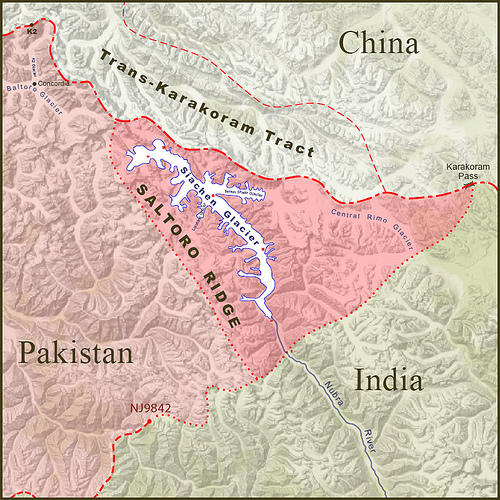
Here it is worth mentioning that this scribe has categorically been denying throughout, all claims by Indian meteorologists that Siachen and other glaciers in Jammu and Kashmir are melting due to the global warming rather than direct human activity. It has been a challenge for scientists working on climate change to understand how the adjoining Baltoro glacier on the other side of Saltoro Ridge which divides the two glaciers, does not seem to be experiencing the same effect.

The causes of recent floods in Pakistan are blamed on El NiƱo but very less attention is being paid to the cloud burst in Siachen and Ladakh Region, which is because of an uneven development including development of airports and helipads on various locations of glaciers. The unprecedented cloud burst broke all records of rainfall of modern recorded history of meteorological data pertaining to the region. Since last couple of years it was emphasized and urged from the Indian government to save and preserve these glaciers, as these are declared climate change indicators.

Although the scientists agreed that recent territorial monsoon rainfall has been because of the confluence of the Western Monsoon system, they failed to correlate on the reasons behind this atmospheric weather divide. It has been reported in various international research institution that rainfalls caused the 2010 floods in Pakistan. The Ministry of Foreign Affairs never raised the question of melting glaciers, which ultimately appeared disastrous for Pakistan.

In 2005, a team from the University of Newcastle, UK established this after finding out from compilation of temperature data for several instrumental records. The Karakoram and Hindu Kush Mountains of the Upper Indus Basin (UIB) had been analyzed for seasonal and annual trends over the period 1961-2000 and compared with neighboring mountain regions of Pakistan and India. Strong contrasts are found between the behavior of winter and summer temperatures and between maximum and minimum temperatures but decision makers of both countries remained unmoved. This is of particular concern on part of the Ministry of Environment and Ministry of Water and Power, which never took this issue to an international level.

Pakistan Government needs to take the case to the International Court of Justice, as the issue remains to be one of the most potent cases of climate change injustice caused to a neighboring country. An international commission should be established based on neutral climate change experts to fix the responsibility and quantify the impacts. Based on the findings, Pakistan should pursue international community to pressure India for an immediate demilitarization of Siachen and declaration of all glaciers as protected areas.

These glaciers could be handed over to UNESCO or concerned parties to avoid any future calamity. Furthermore, Pakistan should claim financial losses made due to the floods.

SDPI is an independent Pakistani think-tank based in Islamabad.
---

Related Posts: Pakistan, The Largest Land of Glaciers Part 1, 2 and 3

Disclaimer: The views expressed in this article are the sole responsibility of the author and do not necessarily reflect those of the ‘Wonders of Pakistan’. The contents of this article too are the sole responsibility of the author(s). WoP will not be responsible or liable for any inaccurate or incorrect statements contained in this post.
YOUR COMMENT IS IMPORTANT
DO NOT UNDERESTIMATE THE POWER OF YOUR COMMENT
Wonders of Pakistan supports freedom of expression and this commitment extends to our readers as well. Constraints however, apply in case of a violation of WoP Comments Policy. We also moderate hate speech, libel and gratuitous insults.


Tuesday, January 6, 2009

Pakistan, The Largest Land of Glaciers [Part 2 of 3]

THE THIRD POLE: The majestic range of Karakorams in Northern Pakistan has the honor of having World's largest glaciers after the poles. This photograph is one of the many taken on location during extreme summer month.

THE LARGEST LAND OF GLACIERS


by Nayyar Hashmey


           How did it start?

In about 1978, the Indian Army mounted an expedition to Teram Kangri peaks (in the Siachen area on the China border and just east of a line drawn due north from NJ9842) as a precursor-exercise (a camouflage to occupy the area by force). The first public mention of a possible conflict situation was an article by Joydeep Sircar in The Telegraph newspaper of Calcutta in 1982, reprinted as "Oropolitics" in the Alpine Journal, London, in 1984. India launched an operation on 13 April, 1984. The Indian Army and the Indian Air Force went into the glacier region. Pakistan army quickly responded with troop deployments and what followed was literally a race to the top.

Current situation

Ever since then, the Indian Army occupies the high altitude side of the Siachen Glacier and the three main passes of the Saltoro Ridge immediately west of the glacier, Sia La, Biafond La, and Gyong La, thus holding onto the advantage of high ground. However, its tactical advantage by contrast demands a heavy toll in terms of money and human loss. Gyong La (Pass) itself is at 35-10-29N, 77-04-15E; that high point is controlled by India. Pakistan controls the glacial valley five kilometers southwest of Gyong La.
Though Pakistani soldiers have waged a valiant struggle to get up to the crest of the Saltoro Ridge, the Indians resist to come down and abandon their strategic high posts. In 2003 a ceasefire went into effect. Even before then, every year more solders were killed because of severe weather than enemy firing. The two sides have lost more than 2,000 personnel primarily due to frostbite, avalanches and other complications.

Who owns Siachen

The glacier is well inside Pakistani territory. But India’s strategic want to keep an eye and a possibility to seek vigilance over Pakistan's strategic route to China (the Karakorum Highway) in 1982 it sent a training expedition to Antarctica to train under "Siachen Glacier Like" conditions. Then in April 1984, it conducted its Operation Meghdoot', and invaded Pakistani territory.

Since the glacier is not physically connected to India (there is no natural ground routes connecting India and Siachen Glacier), therefore, it used its Air Force to drop all of its forces at Siachen and still to this day uses helicopters and aircrafts to transport supplies, food and soldiers.

Historically—geographically—and factually this third pole on earth is well Inside Pakistan where Pakistanis are confronting the Indians who have a force 5 times their size. However, India in the process is paying a heavy price. According to a book on the War on Siachen, 50% of Indian soldiers, who make back alive, suffer from permanent mental retardation, not to mention amputations and other terrible things that Indian soldiers have to go through. 


Top of Form
Bottom of Form
 
Left to Right) Paiju Peak (Trango II?), The Trango Monk, Trango Nameless Tower (6,239 m), and the mass of the Great Trango (6,286 m) on the northern lateral moraine of the Baltoro Glacier in the Baltoro Muztagh  
    Range.

This is the junction of Biafo and Hispar glaciers which together form 118 km of longest layer of ice on the Earth outside the pole.The war has been going on for almost quarter of a century. Though the price has been heavy for both sides (especially for India), Pakistan has been slowly driving the Indians out of Siachen Glacier (Pakistani Territory).

As the conflict between two nuclear neighbors continues, another apathetic side haunts Siachen. Right on the glacier, amid bullets whistling over wild roses and snow leopards’ dens, the already fragile environment is highly endangered due to perpetual warlike conditions since several decades. To save the flora and fauna, the natural habitat in the area, in 2003 this beleaguered bit of no-man’s-land high up in the Himalayas was readied for a radical recasting, when a group of Pakistani and Indian mountain climbers gathered in the Swiss Alps to highlight the plight of Siachen and other threatened cross-border regions.
The solution? Designating the glacier a ‘peace park’ where two hostile nations could cooperate for the sake of sustainable development. However, this process didn’t come to a declaration of an inter-national peace park due to apprehensions and doubts on both sides. Last year, India started inviting foreign climbers to the Siachen to prove its virtual hold over the glacier. This again put things in the back gear.

 Siachen’s Present Scenario

Just a week before Mumbai attacks on 26th November this year, time had been most opportune. Pakistani President Asif Ali Zardari was sincerely pushing for a serious dialogue between two nations, the idea of a ‘peace park’ was ripe for rejuvenation once again. However, the Mumbai attacks have once again brought both nations to the old ‘worst enemy stance’.
 But war in Siachen is a war against nature than a war between 'too' Nuclear Neighbours
Many in Pakistan and India perhaps might take this approach being out of tune, but this writer personally believes, the majority of people in Pakistan as well as the Govt. in Pakistan, do wish a permanent peace between India and Pakistan. I have been advocating for friendship parks between India and Pakistan, one at the Wahga border crossing and the other one at the Siachen. But quite ironically this time its India reversing the cycle and resisting attempts for peace and friendship between two neighbours raising issues such as terrorism; ignoring the very fact that Pakistan too is the target of terrorists as much as India is.

Next, Previous
---

YOUR COMMENT IS IMPORTANT
DO NOT UNDERESTIMATE THE POWER OF YOUR COMMENT
Wonders of Pakistan supports freedom of expression and this commitment extends to our readers as well. Constraints however, apply in case of a violation of WoP Comments Policy. We also moderate hate speech, libel and gratuitous insults.

Monday, January 5, 2009

Pakistan, The Largest Land of Glaciers [Part 1 of 3]

Embedded in the lap of Pakistan's mighty Karakorams (here shown in dark green)  lies Siachen (the small, dark orange part). 


THE LARGEST LAND OF GLACIERS


by Nayyar Hashmey


In Pakistan, we have more glaciers than any other land outside the north and south poles. Our glacial area covers some 13,680 sq. km which represents an average of 13 per cent of mountain regions of the upper Indus Basin. Baltistan, in our north eastern corner and in the heart of Karakorams, provides the world's most magnificent mountain scenery and mountaineering possibilities. Renowned for the largest glaciers and towering peaks, it has four 8000m peaks, and many over 7000m.


The glaciers in Pakistan can rightly claim to possess the greatest mass and collection of glaciated space on the face of earth. In fact, in the lap of our Karakoram mountains alone there are glaciers whose total length would add up to about 6,160 sq. km. To put it more precisely, as high as 37 per cent of the Karakoram area is under its glaciers against Himalayas' 17 per cent and European Alps' 22 per cent. The Karakorams have one more claim to proclaim; its southern flank (east and west of the enormous Biafo glacier) has a concentration of glaciers which works out to 59 per cent of its area.


Eric Shipton, a great mountaineer who perished in Pakistan's Northern Areas, while describing the peaks and glaciers in Pakistan wrote in his account “To describe this region is to indulge in superlatives, for everywhere you look are the highest, the longest and the largest mountains, glaciers and rivers in the world”. Making some allowance for Shipton's tendency towards slight exaggeration, born out of awe and fascination, the fact remains that Pakistan boasts of the largest share of the highest number of glaciers after the poles.

This largest ice mass in the subcontinent however, continues to mar relations between India and Pakistan.
 Located in the disputed region of Kashmir its average winter snowfall is 10.5m (35 ft.) and temperatures can dip to minus 50C (minus 58F). In spite of this severe climate, the word 'Siachen' ironically means 'the place of wild roses, a reference some people attribute to the abundance of Himalayan wildflowers found in the valleys below the glacier, but specifically refers to the thorny wild plants which grow on the rocky outcrops.

Presently the glacier is also the highest battleground on earth, where India and Pakistan have fought intermittently since April 13, 1984. Pakistan maintains permanent military personnel in the region at a height of over 6,000m and so does India. The site is a prime example of mountain warfare.

The glacier's melting waters are the main source of the Nubra River, which drains into the Shyok River. The Shyok in turn joins the Indus River. The glacier's melting waters are a major source of the river Indus, a vital water source for Pakistan


The conflict in Siachen stems from the confusion in the improperly demarcated territory on the map beyond the map coordinate known as NJ9842. The 1949 Karachi Agreement and the 1972 Simla Agreement did not clearly mention who controlled the glacier, merely stating that from the NJ9842 location the boundary would proceed "thence north to the glaciers." In the 1960's and 1970's, however, the United States Defense Mapping Agency (now National Geospatial-Intelligence Agency) issued maps showing detailed position of the area and made their maps available to the public and pilots as proceeding from NJ9842 east-northeast to the Karakoram Pass at 5534m (18,136 ft.) on the China border. Other international (governmental and private cartographers and atlas producers) confirmed this position. This implied in a cartographical and categorical allocation of the entire 2700 square kilometers (1040 square miles) Siachen area to Pakistan. However, prior to 1984 neither India nor Pakistan had any permanent presence in the area presumably due to the extremely harsh conditions which prohibited any such presence.


In the 1970s and early 1980s several mountaineering expeditions applied to Pakistan to climb high peaks in the Siachen area and Pakistan granted them, which reinforces our claim on the area, as these expeditions arrived on the glacier with a permit obtained from the Govt. of Pakistan.

The glacier is well inside Pakistani territory. However, India with a design to keep an eye over Pakistan's strategic route to China (the Karakorum Highway) in 1982 sent a training expedition to Antarctica to train under "Siachen Glacier Like" conditions. Then in April 1984, it conducted its Operation Meghdoot', and invaded Pakistani territory.


Since the Glacier is not physically connected to India (there is no natural ground routes connecting India and Siachen Glacier), therefore, it used its air force to drop all of its forces at Siachen. And still to this day uses helicopters and aircrafts to transport supplies, food and soldiers. 

On this third pole on earth, Pakistani military is confronting the Indians who have a force 5 times its size. In the process India is paying a heavy price. According to a book on the War at Siachen Glacier, 50% of Indian soldiers, who make back alive, suffer from permanent mental retardation, not to mention amputations and other terrible things that Indian soldiers have to go through. 

The war has been going on for about quarter of a century. Though the price has been heavy for both sides (especially for India), Pakistan has been slowly driving the Indians out of Siachen Glacier.

---

YOUR COMMENT IS IMPORTANT
DO NOT UNDERESTIMATE THE POWER OF YOUR COMMENT
Wonders of Pakistan supports freedom of expression and this commitment extends to our readers as well. Constraints however, apply in case of a violation of WoP Comments Policy. We also moderate hate speech, libel and gratuitous insults.


Search

Custom Search